|

Czech Republic
8.2 km (5.1 miles) NW of Beroun, Stredocesky Kraj, Czech Rep.
Approx. altitude: 299 m
(980 ft)
(maps:
street)
Click on any of the images for the full-sized picture.
![]()
![]()


| 50°N 14°E | (secondary) |

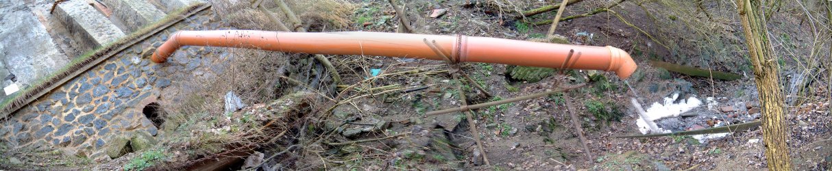
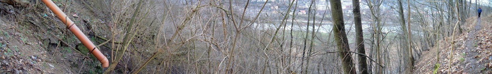
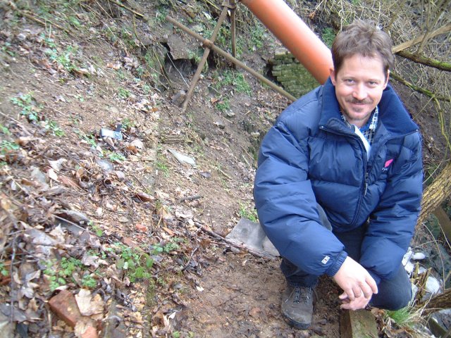
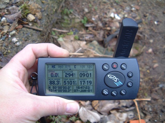
(visited by Mark Pautz and Debra Childs) 07-Jan-2001 -- When I received an e-mail from my friend in Amsterdam (Etienne Posthumus) informing me of the Confluence Project, I sent a message straight back to him saying: "You really should not have sent this to me....REALLY!!! I have too few hours in the day as it is!" :-((( Yes, I admit it, I'm a compulsive person, and I just could not resist the temptation of becoming involved in this project! Some background first. My name is Mark Pautz. My wife, Débra Childs, and I are South Africans who have been living and working in Prague in the Czech Republic for over five years now. We are travel junkies, and get on the road as much as our tight work schedules permit. I bought a Garmin GPS III over three years ago, and it goes wherever we go. Forget the mobile phone, all I need is my GPS! Straight after receiving Etienne�s message on Friday night I toggled around the GPS screen and found the confluence of N 50° and E 014°. Great, it was just to the west of Prague, and only 33.2 km from our apartment, as the (sober) crow flies. Saturday was a sleep-in day as the weather was cold, wet and miserable. When I woke at about 11h00 on Sunday, January 7, 2001, the weather (through the skylight above our bed) looked a little better - grey, but at least it was not raining! We hit the road after lunch, electing to try and get directly to N50 E014 - without looking at a map. We eventually got there, but kicked ourselves when we did as this was an area we visit quite frequently on our motorcycle, and we could have got there in less than half the time on the highway! The village is called Nizbor and it is on the Berounka River just to the south east of one of our favourite local destinations, Křivoklát Castle. It's a pretty spot, and an area where many people come to swim, suntan and barbeque in the summer. This was going to be easy! The spot was just 120 metres away, across the main bridge in Nizbor and just up the slope on the other side. No problem? Ha!! Okay, so it had been raining and the slope was steep and very slippery. Contingency plan - we drove to the top of the hill to see if there was an easier approach from that side. We were in luck, as a small track took us into the grounds of an old chateau, and to within 80 metres of N50 E014. The "Zámek Nizbor" (or Nizbor Chateau, I believe) was built in 1720 on the site of a fortification that had first been erected in 1425. It must once have been a magnificent complex, on the most inaccessible (and thus defensible) vantage point in the area but now, although still occupied, is looking very run down. The legacy of WW-II followed by 50 years of Communism I guess. The chateau must have had some strategic significance as it lies directly on the route between Křivoklát Castle and Karlstejn Castle (to the south east) - all three lie on the Berounka River. Now, as much as I love my GPS, these useful little devices have their limitations. Firstly they have to be moving to activate the moving map and to direct the user to the selected waypoint. Secondly they need to have an open sky, disliking the interference of trees and buildings. Yeah - fine! Here we were creeping around the back of a crumbling chateau, on a slippery, muddy track right against the high wall of the chateau, on a densely wooded slope. The GPS was not really co-operating! After much pacing up and down, a few futile attempts at climbing the slope and a number of hair-raising (and muddy) down hill slides, we got as close as humanly possible to N50 E014. As luck would have it, where did the magical spot fall? Yes, you've guessed it, on a crumbling and inaccessible section of the slope behind the chateau - at the very spot where the chateau's free-flow drainage pipe dumped its noxious waste! Aaargh!! We hoped and trusted that the toilets were not connected to this outlet pipe as well! I can confirm that the magical N50°00�00.0" E014°00�00.0" did flash onto the screen of the GPS twice but, by the time I had readied the digital camera, the waypoint had shifted slightly and I was getting decimal places! Damn! We tested our patience (and our tolerance for cold and mud) for about an hour, until I settled for the best possible reading: N50°00�00.0" E014°00�00.3". This was not just a matter of walking down a path and waiting for the most accurate reading! I had my feet braced against a root and was leaning forward into an abyss, with Debra hanging on to the waistband of my Levis lest I slip once again! It was comical, great fun, and REALLY the best we could do! I could maybe get just that one metre closer in summer, but certainly not in winter!! I have used "Panorama Factory" to stitch some panoramic shots together. Photo #1: The back of Nizbor Chateau showing the drain pipe that cuts through N50 E014. The steep, wet terrain made it impossible to actually reach the pipe. Photo #2: Six shots exposed at a focal length of 36mm showing the waste pipe coming out of the back of the Nizbor Chateau. Viewed from left to right, you are actually looking at the vertical drop from top to bottom! N50 E014 is close to the pipe support in the centre of the picture, but towards the photographer. Photo #3: Six shots exposed at a focal length of 36mm showing the GPS on N50 E014 and panning around 180 degrees to show Debra on the path behind me. The Berounka River is visible through the trees as is the town of Nizbor. Photo #4: A view of Zámek Nizbor from the bridge over the Berounka River in Nizbor. N50 E014 is on the slope below the building with the red roof. Photo #5: The entrance to Nizbor Chateau from the top of the hill. We took the path to the right of the picture and along the brick wall. At the end of the building we then turned left and onto the narrow, slippery path on the slope of the hill facing the river. Photo #6: That�s me, Mark Pautz, at the closest possible point to N50 E014. I leaned out and placed the GPS as close as I could to the confluence, with Débra hanging on to the back of my Levis just in case I slipped in the mud! Photo #7: Although the GPS twice displayed the magical 50°00�00.0" E014°00�00.0", I was too slow with the camera, and missed it! After patiently waiting for an hour, this was the best reading photographed on the day: 50°00�00.0" E014°00�00.3". Thanks for the challenge. You�ll be hearing from us again! |
| All pictures |
|
#1: The back of Nizbor Chateau showing the drain pipe that cuts through N50 E014. #2: Six shots showing the waste pipe coming out of the back of the Nizbor Chateau. #3: The GPS on N50 E014 and panning around to show Débra. #4: A view of Zámek Nizbor from the bridge over the Berounka River in Nizbor. #5: The entrance to Nizbor Chateau from the top of the hill. #6: Me, Mark Pautz, at the closest possible point to N50 E014. #7: Close enough GPS reading. |